
Ensemble Learning for Rural Land Valuation: Decoding the Drivers of Plot Prices
Valuation of Building Plots in a Rural Area Using Machine Learning Approach
This paper presents a machine learning-based mass appraisal approach for valuing building plots in rural areas of the Wrocław agglomeration, Poland. Using ensemble methods like Random Forest and Bagging, the study integrates real estate registry data with publicly available geographical datasets to evaluate the impact of location and environmental attributes on property prices.
TL;DR
Determining the value of building plots in rural areas is often a "black box" of subjective expert opinion. This research leverages modern machine learning—specifically Random Forest and Bagging—to analyze 9,114 real-world transactions near Wrocław, Poland. The study effectively demonstrates that while nature is a "nice-to-have," location and accessibility remains the king of valuation, even in rural landscapes.
The Valuation Gap: Beyond Expert Subjectivity
Traditional appraisal methods were designed for an era of data scarcity. Experts often rely on a handful of "comparable" properties, which introduces significant bias. In the age of Big Data and Open GIS (Geographic Information Systems), we now have access to thousands of variables: distance to the nearest highway, the shape of the plot, and even the density of forests within a 500m radius.
The authors identify a critical tension: Do buyers in rural areas value nature (rivers, forests) or convenience (schools, transport)? Understanding this isn't just academic; it’s vital for developers and state agencies performing mass appraisals for taxation.
Methodology: The Data-Driven Approach
The study utilizes a robust pipeline of 28 attributes divided into 11 categories. Two ingenious features stand out:
- Shape Index: A mathematical representation of how "square" a plot is. Narrow or irregular plots are harder to build on and thus worth less.
- Average Price (Cadastral Proxy): To account for missing data like access to electricity or gas, the authors used the average price of the cadastral region as a proxy for local infrastructure quality.
The researchers tested various algorithms, ranging from simple Linear Regression (LIN) to sophisticated Ensemble Methods like Random Forest (FOR).
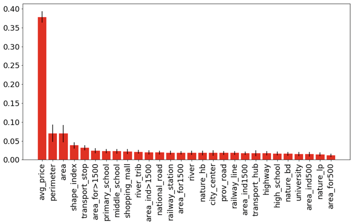 Fig 1: Feature importance ranking shows that location-based features (transport, proximity to city center) dominate the model's decision-making.
Experimental Insights: What Actually Moves the Needle?
The results were conclusive across eight different data permutations. The ALEMO dataset—which combines Area, Location, Environmental, Average price, and Other (shape) features—yielded the most accurate results.
Key Findings:
- Ensemble Supremacy: Random Forest and Bagging consistently outperformed Linear Regression and Decision Trees. This is due to their ability to combine multiple "weak" predictors into a single robust model, mirroring the complex, multi-factor nature of real estate.
- Location > Environment: Proximity to transport hubs and the city center had a much higher rank in "Feature Importance" than proximity to rivers or landscape parks.
- The Shape Matters: Including the perimeter and shape index (the 'O' in ALEMO) consistently lowered the Mean Absolute Error (MAE).
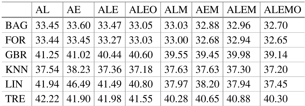 Table 1: Mean Absolute Error (MAE) across different models and datasets. Lower values indicate higher accuracy. Note the superior performance of FOR and BAG.
Critical Analysis & Conclusion
While the study proves that machine learning can accurately model rural plot prices (MAE ~32.65), it also highlights a significant limitation: Infrastructure Data. Factors like "access to water/gas" are currently hidden within the "Average Price" proxy.
The Takeaway
For real estate technology (PropTech) platforms, the message is clear: Invest in GIS integration. By automatically pulling distances to amenities and calculating plot geometries, models can reach an accuracy level that rivals—and sometimes exceeds—traditional human appraisal.
The future of the field lies in automated feature extraction from geodetic maps, moving from proxies to direct measurements of utility availability.