
Precise Visual Pollution Mapping: Bridging the Gap Between Photographer and Object
Visual pollution localization through crowdsourcing and visual similarity clustering
This paper introduces a multi-phase localization method for physical advertising media (visual pollution) using outdoor crowdsourcing. By combining mobile sensor data (GPS, magnetometer) with computer vision-based displacement estimation, it achieves a Mean Error (ME) reduction from 10.8m to 8.5m compared to standard GPS-only baselines.
TL;DR
Locating illegal billboards in a city is harder than just "taking a photo." Standard GPS gives you the location of the photographer, not the billboard. This paper proposes a clever fix: using computer vision to estimate the distance between the camera and the advertisement, then using trigonometry and magnetometer data to project the true geographic coordinates. The result? A 21% improvement in localization accuracy over traditional methods.
The Problem: The "Displacement" Blind Spot
When we use crowdsourcing apps to map city issues, we rely on the phone's internal GPS. However, two major errors occur:
- Technical Inaccuracy: GPS sensors have a "Time To First Fix" (TTFF) delay and inherent signal noise.
- Physical Displacement: A billboard isn't at your feet; it's 20 meters away. If five people take photos of the same billboard from different angles, a simple average of their GPS points will result in a "ghost" location in the middle of the street rather than on the sidewalk.
Methodology: From Pixels to Coordinates
The authors break down the localization task into a pipeline that transforms a simple smartphone photo into a precise geographic data point.
1. Computer Vision Displacement
The core innovation lies in the Displacement Computation Phase. By applying Sobel filters and edge detection, the system identifies the bounding box of the advertisement. Since the worker specifies the type of medium (e.g., a "Bigboard"), the system knows its real-world height. By comparing the object's pixel height to its known physical height and the camera's focal length, the system calculates the exact distance (d) to the object.
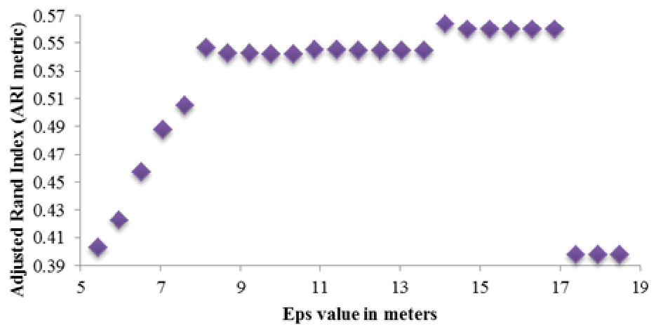 Figure: The geometric principle of projecting the object coordinates using distance and magnetometer heading.
2. Intelligent Clustering (DBSCAN)
To ensure multiple photos of the same billboard are treated as a single entity, the researchers used DBSCAN (Density-Based Spatial Clustering of Applications with Noise). They didn't just look at distance; they introduced a "Similarity" formula that accounts for the type of advertisement (e.g., matching two "Citylights" but separating a "Citylight" from a "Billboard" even if they are close).
Experiments: Real-World Testing in Bratislava
The team tested the system in Bratislava, Slovakia, a city estimated to contain tens of thousands of outdoor ads.
Key Findings:
- Accuracy Boost: The Mean Error (ME) dropped from 10.8 meters (baseline) to 8.5 meters.
- Success of Edge Detection: Automatic contour detection worked on 44.39% of photos, highlighting the need for good lighting and "clean" shots.
- SOTA Comparison: While the baseline method occasionally placed ads 15-20 meters away from their true location, the proposed method brought that error down significantly in most clusters.
 Table: Quantitative comparison between the Baseline (GPS-only) and the Proposed Method.
Critical Insight & Future Outlook
The beauty of this research is its low barrier to entry. It doesn't require expensive LiDAR or specialized mapping vehicles; it transforms standard smartphones into scientific instruments.
The Limitations: Currently, the success of the edge detection relies heavily on the "Crowdsourcing Phase" rules (daylight, perpendicular angles).
The Future: The authors suggest moving toward "Content Similarity." Instead of just matching the type of billboard, future iterations could use visual feature matching (like SIFT or GIST) to recognize that two photos show the same brand or image, further refining the cluster accuracy. This work paves the way for a more aesthetic, citizen-led urban management system.
Conclusion
By treating the user's phone as a sensor in a broader physical system rather than just a data entry point, the study proves that computer vision can effectively compensate for the inherent limitations of mobile GPS.