
WEDSS: Bridging Crowd-Sensing and Data Mining for Real-Time Environmental Vigilance
Abstract The large-scale management and monitoring of environment is a complex issue for administrators and public authorities responsible for the detection of emergencies. They need to rank all possible environment issues and then solve them. A Decision Support System can be used to simplify such operations, to perform better analysis and to provide more widespread coverage to data. This paper presents a Web Environmental Decision Support System designed to estimate environmental condition, which includes a Data Mining Module (DMM) that computes an Environmental Condition Index by processing historical and real time data and a Hazard Detection Module (HDM). The HDM comprises a mobile APP that allows users to report environmental events of emergency, hazards and waste, in order to help public authorities in managing and planning activities. The collected data are processed by the Web Environmental Decision Support System which assigns automatically an Environmental Emergency Index to every report. This approach allows monitoring of wide environmental areas letting communities be part of the s
This paper presents a Web Environmental Decision Support System (WEDSS) that integrates a Data Mining Module (DMM) and a Hazard Detection Module (HDM) to monitor large-scale environmental conditions. The system leverages both automated sensor networks and crowd-sourced reporting via a mobile APP, utilizing the Analytic Hierarchy Process (AHP) to quantify environmental emergencies.
TL;DR
The Web Environmental Decision Support System (WEDSS) introduced in this paper represents a shift from static environmental reporting to dynamic, participatory monitoring. By combining a mobile-based Hazard Detection Module (HDM) with a sensor-driven Data Mining Module (DMM), the system provides two distinct metrics: the Environmental Condition Index (ECI) for general area health and the Environmental Emergency Index (EEI) for specific reported hazards.
Problem & Motivation: The Fragmentation of Environmental Monitoring
Managing large-scale environmental emergencies is a logistical nightmare for public authorities. Traditionally, data exists in silos (e.g., separate agencies for air and water) and often follows the DPSIR (Driver-Pressures-State-Impact-Response) framework, which is excellent for documentation but lacks the "intelligence" to rank issues by urgency automatically.
The authors identify a critical gap: public authorities lack a tool that integrates heterogeneous sensor data with the observations of citizens on the ground.
Methodology: Dual-Channel Intelligence
The WEDSS architecture is divided into two operational cores:
1. The Data Mining Module (DMM) - Automated Intelligence
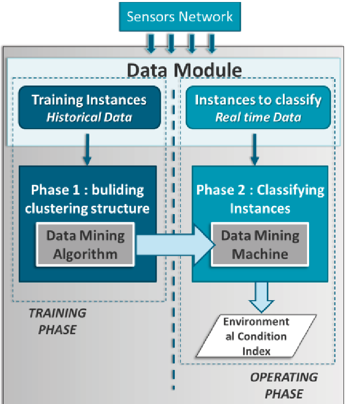
The DMM acts as the "brain," ingesting data from a vast sensor network. Because sensors provide data in various formats and physical quantities, the DMM uses a training/operating phase structure. A Cluster Analysis algorithm is employed to categorize environmental aspects and rank health conditions into a unified Environmental Condition Index (ECI).
2. The Hazard Detection Module (HDM) - Human Intelligence
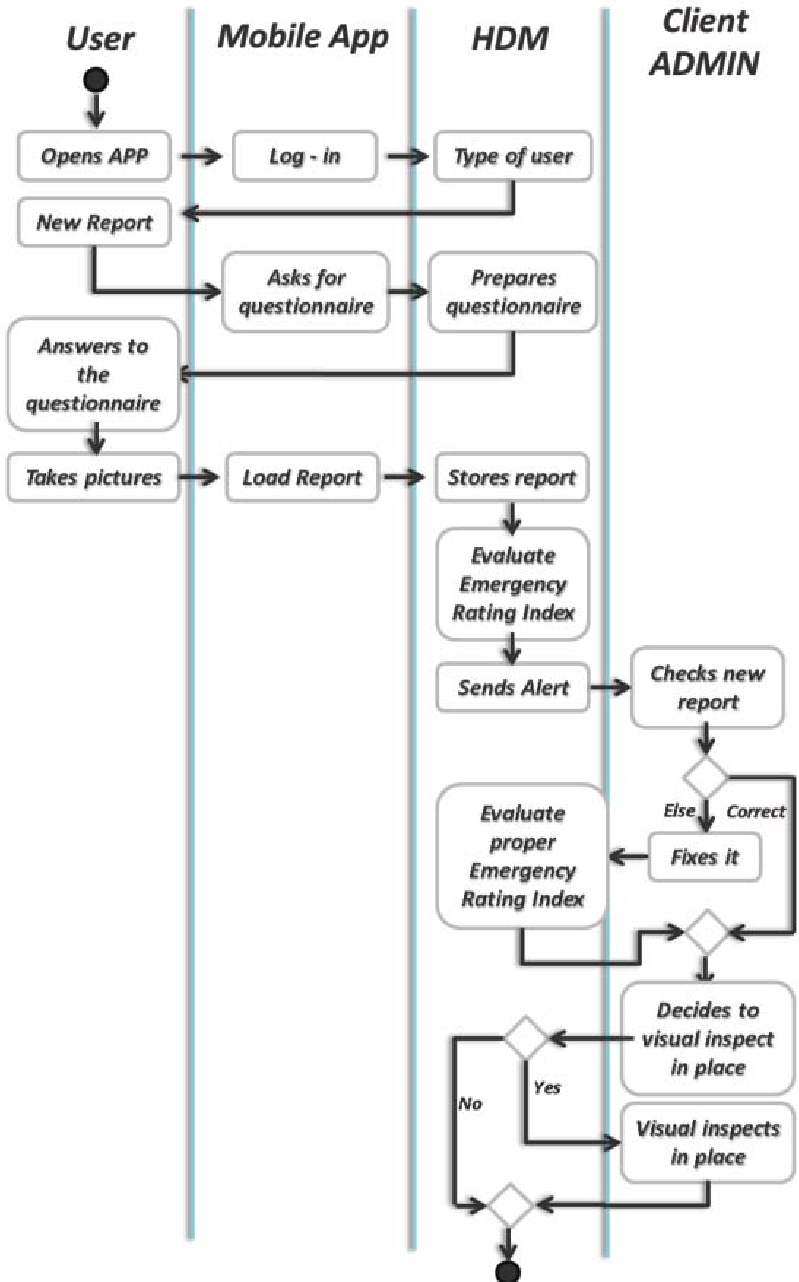
This is where the system shines. Through a mobile APP, citizens and experts provide "visual inspections." These are georeferenced and timestamped. To turn subjective photos into objective data, the authors use the Analytic Hierarchy Process (AHP).
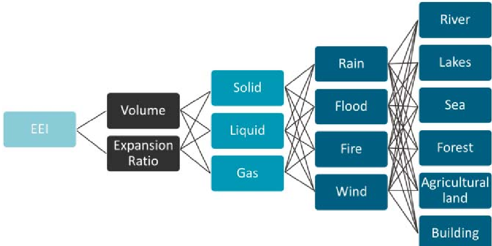
The AHP Logic: AHP breaks down the decision problem into a hierarchy:
- Goal: Calculate the EEI.
- Criteria: The physical state of the hazard (Solid, Liquid, Gas).
- Sub-Criteria: Environmental conditions (Rain, Flood, Fire, Wind).
- Alternatives: Sensitive targets (River, Forest, Buildings, etc.).
Experiments & Results: Quantifying Criticality
The system was tested using pairwise comparisons to weight different environmental risks. The researchers calculated a Consistency Ratio (CR) to ensure the mathematical validity of their weights. The result? A CR of 0.05, indicating high reliability (anything below 0.10 is considered excellent in decision science).
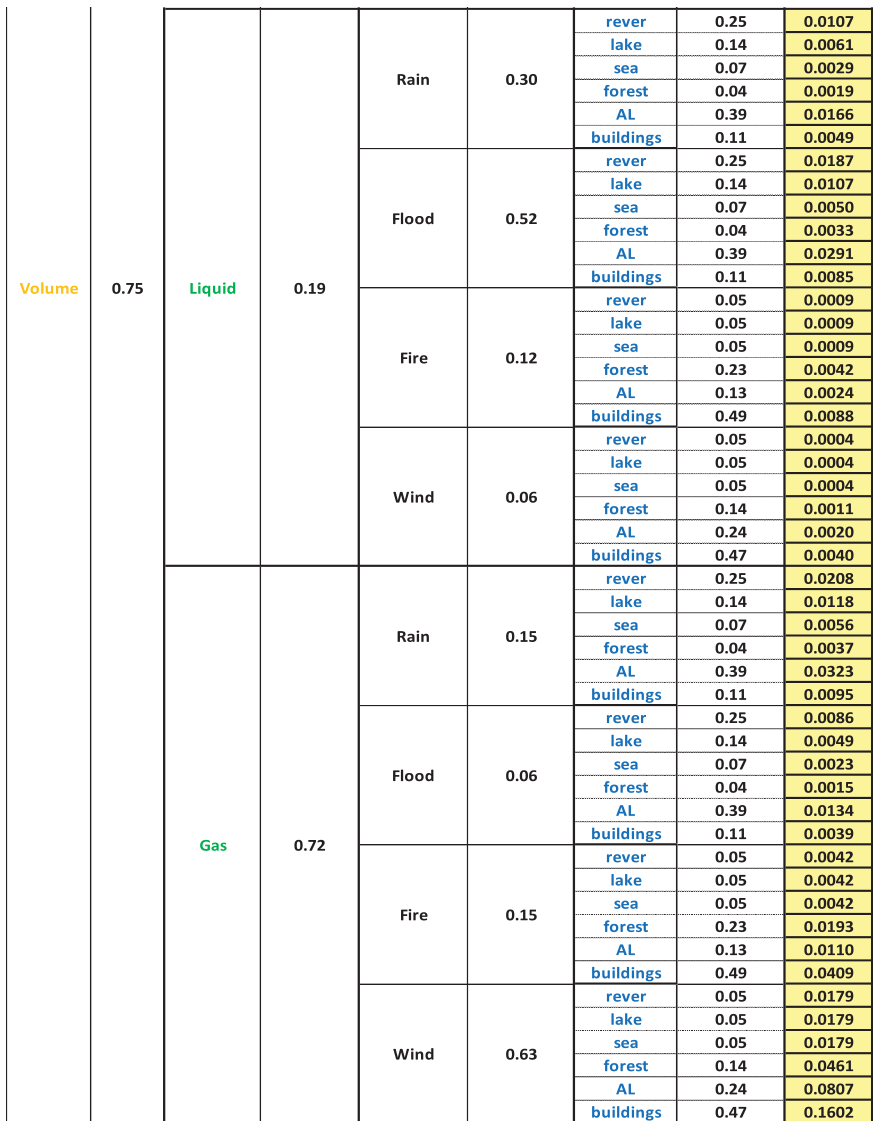
By applying these weights, the system can automatically flag high-risk reports. For instance, reports involving hazardous gas under windy conditions near residential buildings yielded the highest EEI, alerting administrators to prioritize these over, say, specialized solid waste in a forest.
The detailed EEI calculation table (below) illustrates how different combinations of volume, state, and proximity to sensitive targets (like agricultural land - AL) result in varied urgency scores.
Critical Analysis & Conclusion
The WEDSS successfully demonstrates that ICT and Participatory Sensing can transform environmental stewardship. Its core strength lies in its ability to translate qualitative human observations into quantitative indices that a computer can rank.
Key Takeaways:
- Prioritization: The EEI allows limited municipal resources to be deployed where the risk is highest.
- Citizen Empowerment: The APP bridges the gap between the community and the government.
- Scalability: The modular DMM can be expanded to include new types of sensors as technology evolves.
Limitations & Future Work:
The paper currently relies heavily on the "honesty" and "accuracy" of user input in the APP. Future iterations might benefit from integrating Computer Vision (AI) to automatically verify the content of the photographic reports, reducing the burden on human verification and filtering potential "spam" or low-quality reports.