
Diversity Matters: Building Smarter RSS Maps through Device-Aware Crowdsourcing
A weighting system for building RSS maps by crowdsourcing data from smartphones
This paper introduces a weighted crowdsourcing framework for constructing Received Signal Strength (RSS) maps using smartphone data. By assigning dynamic weights based on the "trustworthiness" (GPS accuracy) of diverse mobile devices, the system creates highly accurate radio maps suitable for indoor/outdoor localization and network monitoring.
TL;DR
Building Radio Signal Strength (RSS) maps usually requires expensive manual labor. Crowdsourcing is a solve, but it introduces a "garbage in, garbage out" problem due to varying smartphone quality. This paper introduces a weighting system that prioritizes data from accurate smartphones (e.g., Samsung S9) over older models (e.g., Nexus 2010), improving localization accuracy by over 36%.
Context & Motivation: The Heterogeneity Headache
RSS maps are the backbone of modern indoor navigation, access control, and network optimization. However, the academic community has long struggled with the heterogeneity of crowdsourced data.
Previous SOTA (State Of The Art) methods often assumed that all participating nodes were created equal. In reality, a flagship phone from 2024 has significantly better GPS and Wi-Fi chipsets than a budget phone from 2018. If a system treats a data point with a 30-meter GPS error the same as one with a 5-meter error, the resulting RSS map becomes a blurred, unreliable mess.
Methodology: Trust as a Metric
The authors' core insight is simple yet powerful: Quantify the trustworthiness of the source.
1. The Architecture
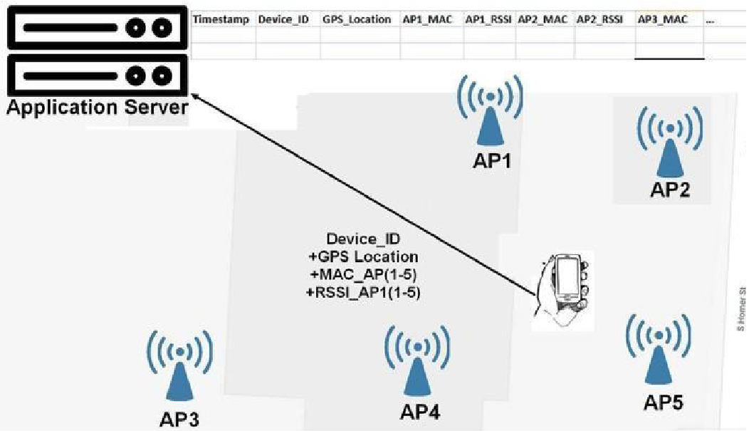
The system follows a Client-Server model where smartphones upload:
- Unique Device ID
- GPS Coordinates
- Scanned Wi-Fi MAC addresses & RSSI values
2. Weighted Updating Mechanism
The server maintains a pre-configured database of device capabilities. When a new data point arrives, the server applies two critical parameters:
- Effective Radius (): Less accurate devices update a larger area on the map (diffusing their uncertainty).
- Weighting Factor (): More accurate devices have a higher "vote" in the final RSS value of a cluster.
The update formula is a classic weighted moving average:
Experimental Proof: From Nexus to Galaxy
The researchers benchmarked devices across a 100x100m campus area. The data clearly shows a correlation between a device's age and its GPS accuracy:
- Oldest (Nexus, 2010): ~24m outdoor error.
- Newest (Galaxy S9, 2018): ~6m outdoor error.
Performance Gains
By applying the weighting system, the "Mean Absolute Percentage Error" (MAPE) of the RSS map dropped significantly.
| Metric | Unweighted (Baseline) | Weighted (Proposed) | Improvement |
|---|---|---|---|
| RSSI Error (MAPE) | 19.1% | 12.39% | 35.1% |
| Location Error (m) | 21.52m | 13.69m | 36.4% |
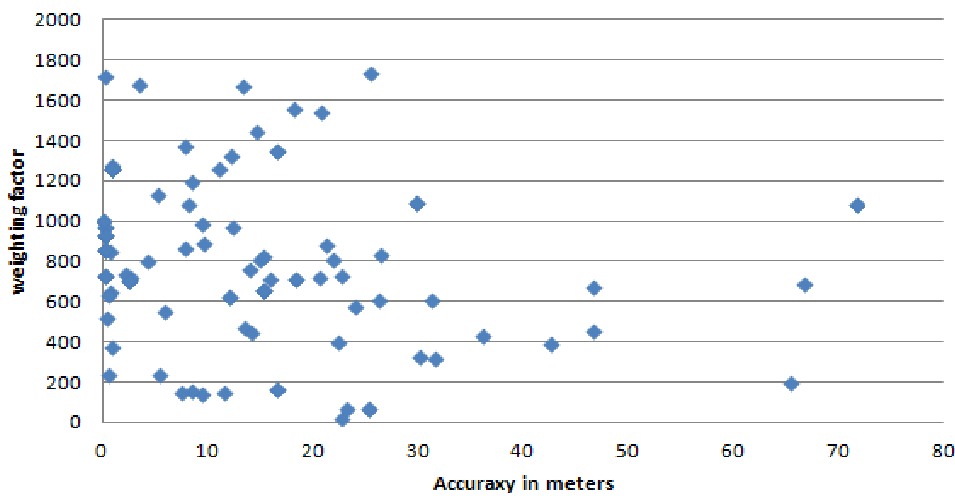 Fig 3 above demonstrates that as the cumulative weight () of a cluster increases, the location error consistently drops, validating that high-trust data eventually dominates the map.
Deep Insight: Why This Works
The brilliance of this approach lies in its inclusive design. Instead of excluding "bad" data (which would reduce the total data volume), it intelligently integrates it. The older devices provide a "rough sketch" of the environment, while the newer devices provide the "high-definition details." This ensures the system remains robust even in areas with low participation.
Critical Analysis & Future Outlook
Strengths:
- Zero Infrastructure: No need for extra hardware like IMUs or QR tags.
- Real-world Ready: Explicitly handles the messiness of hardware diversity.
Limitations:
- Manual Calibration: The weighting factors are currently "pre-configured" based on device ID. In a world with thousands of Android models, an automated "Self-Calibration" or "Dynamic Trust" mechanism (perhaps using ML) would be necessary for global scaling.
- Indoor GPS reliance: The system still relies on GPS for initial ground-truthing, which remains a struggle in deep indoor environments.
Conclusion
This work provides a pragmatic blueprint for large-scale urban sensing. By treating "data quality" as a variable rather than a constant, the authors have paved the way for more reliable crowdsourced maps that don't discriminate against users with older hardware.