
WiFi-RITA: Rescuing Indoor Positioning from the Chaos of Noisy Crowdsourcing
WiFi-RITA Positioning: Enhanced Crowdsourcing Positioning based on Massive Noisy User Traces
The paper introduces WiFi-RITA, a crowdsourcing-based indoor positioning system that reconstructs radio maps from massive noisy user traces without site surveys. It utilizes a novel iterative trace merging algorithm and a sensor fusion framework (Particle Filter) to achieve high-precision positioning in large-scale environments.
TL;DR
Building indoor radio maps usually requires professionals to walk every inch of a building—a process that doesn't scale. WiFi-RITA flips the script by using "noisy" data from everyday users. By treating short, erratic walking traces as rigid bodies in a physical force field, the system automatically aligns them into a high-precision radio map, achieving a median positioning accuracy of 2.0 meters without any manual effort.
The Problem: The "Messy" Reality of Crowdsourcing
Indoor positioning via WiFi fingerprinting is the gold standard for GPS-denied environments. However, the bottleneck is the Radio Map.
Previous crowdsourcing attempts like Walkie-Markie or PiLoc made a fatal assumption: that user traces have small rotation errors. In reality, users hold phones in pockets, bags, or at odd angles, leading to massive heading drift. Furthermore, most users only provide short, disjointed "snippets" of data rather than long, continuous loops, making traditional trajectory alignment fail.
Methodology: The Physics of Trace Merging
The researchers' core insight was to treat every user trace as a rigid body. Instead of complex geometric stitching, they used a "Force-Directed" approach.
1. WiFi-Marks as Anchors
The system identifies "WiFi-Marks"—specific Access Points (APs) detected across different traces. Since the same AP should logically exist at a single coordinate, it acts as a virtual "magnet."
2. Iterative Rotation and Translation (The "RITA" Algorithm)
WiFi-RITA defines a virtual Force and Moment (torque) acting on each trace:
- Translation: A trace is "pulled" toward the average location of the WiFi-marks it contains.
- Rotation: A trace is "twisted" to align its internal marks with the global consensus.
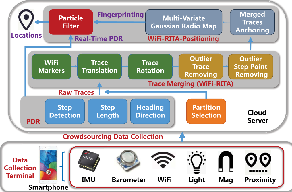 Figure 1: The system architecture from data collection to final positioning.
3. Cleaning the Noise
Even after merging, some traces are outliers. The authors used:
- Barometers to detect floor changes (slopes).
- Gyroscopes to detect turns.
- Isolation Forests to filter out noisy RSSI signals within specific map grids.
Experiments: Real-World Battlesmarts
The system was tested in two massive shopping malls (). The raw data was a chaotic "hairball" of traces (see Figure 6 in the paper), yet the iterative optimization successfully untangled them.
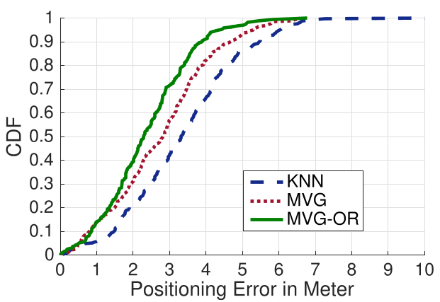 Figure 2: Positioning error comparison showing WiFi-RITA (PDR+WiFi) outperforming standalone methods.
Key Results:
- Landmark Accuracy: The rebuilt "points of interest" were accurate within 1.1m to 1.3m.
- Positioning Performance: By fusing the crowdsensed map with real-time Pedestrian Dead Reckoning (PDR) via a Particle Filter, the system achieved a median accuracy of 2.02m. This is a significant leap over the 3.4m typically seen with standard KNN-based fingerprinting.
Critical Insight: Why it Works
WiFi-RITA succeeds because it doesn't try to "fix" the PDR drift directly. Instead, it accepts that individual traces are flawed and uses the statistical mass of hundreds of traces to find the "physical truth." The use of a Multivariate Gaussian Model for the radio map allows the system to handle the inherent variance of WiFi signals better than deterministic "nearest neighbor" lookups.
Conclusion & Future Work
WiFi-RITA proves that we don't need professional surveyors to map our world. By combining physical intuition (forces) with robust statistics (Gaussian models), we can turn the noise of thousands of smartphones into a precise navigation tool.
Limitations: The system still relies on "landmarks" like turns or slopes to anchor the relative map to a real-world floor plan. Future iterations might look into using opportunistic GPS "hits" near windows or entrances to automate the final anchoring process.